THE GREATER SOUTHERN WATERFRONT

Draft Master Plan 2019 – Proposals for an Inclusive, Sustainable and Resilient City
Published: 27 March 2019

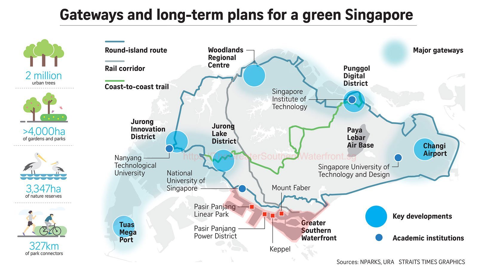
The Greater Southern Waterfront spans across the southern coastline from Pasir Panjang to Marina East. In future, after the City Terminals and Pasir Panjang Terminal relocate to Tuas, about 1,000 ha of land will be freed up for development. Together with other areas like Keppel Club and Sentosa, the total area of the Greater Southern Waterfront will be about 2,000 ha. Some of the Greater Southern Waterfront’s development will start within the next five to 10 years with new developments at Pasir Panjang Power District and the Keppel Club site.
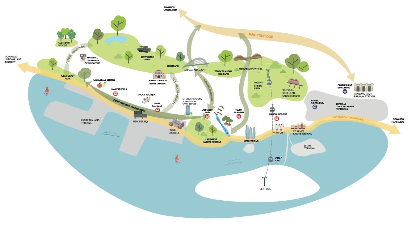
The Pasir Panjang/Labrador area will be rejuvenated as a significant waterfront node along the Greater Southern Waterfront. Singapore’s first 230 kV underground substation, integrated with a commercial building, will be developed next to the Labrador Park MRT station.
Nearer the waterfront, the Pasir Panjang Power District can leverage its unique industrial heritage and be given a new lease of life as a lifestyle and heritage destination. Agencies are exploring various strategies to realise this, including the adaptive reuse of the former power station buildings and opening up the grounds for public access. The new uses will be sensitive to the adjacent Labrador Nature Reserve.
The Power District will be connected to the rest of the Greater Southern Waterfront via the new Pasir Panjang Linear Park. URA and the Singapore Land Authority will be launching a competition in April 2019 for members of public to contribute ideas on how the precinct can be transformed into a lifestyle destination along the Greater Southern Waterfront.
The site occupied by the Keppel Club will be redeveloped for housing after the current lease expires. With its waterfront location and convenient access to the Telok Blangah and Labrador Park MRT stations, it offers unique possibilities for new homes to be developed. Development of the site will be sensitively carried out taking into consideration the nearby Belayer Creek.
source: https://www.ura.gov.sg/Corporate/Media-Room/Media-Releases/pr19-13
The Master Plan is a land use plan that serves as a blueprint to guide Singapore’s physical development. Reviewed every five years, it is a statutory plan that shows the land use and development intensity allowed for every plot of land in Singapore.
In March 2019, the Urban Redevelopment Authority (URA) unveiled key proposals under the Draft Master Plan 2019 (DMP19), which outline the strategies for Singapore’s development in the next 10 to 15 years.
CEAnergy walks you through some of the highlights of the DMP19 and the exciting plans in the pipeline that will transform our living, working, and recreational spaces.
Injecting more vibrancy into the Central Area

Under the DMP19, the government will be looking at increasing live-in population within the Central Area by planning for a variety of homes and amenities in areas such as Downtown, Marina South, and Rochor so more people can live near their workplaces.
The URA has rolled out two incentive schemes to encourage a better mix of uses within the Central Business District (CBD) and other strategies areas to enhance urban vibrancy.
The first is a new CBD Incentive Scheme that offers an increase in gross plot ratio to building owners when they convert existing office developments in the Anson Road, Cecil Street, Shenton Way, Robinson Road, and Tanjong Pagar areas to hotel and residential uses. This will help to rejuvenate the CBD so that it is not only a place to work, but also a vibrant place to live and play in.
The other initiative is the Strategic Development Incentive Scheme. The intent is to encourage commercial building owners to collaborate and comprehensively redevelop adjacent properties in a bold and innovative way that will positively transform the street or even the entire precinct. To encourage such proposals, the government will offer a mix of incentives, including an increase in gross plot ratio and flexibility in terms of planning parameters such as land use and building height for the site.
Other plans to up the buzz in the Central Area include enhancing Orchard Road as a lifestyle destination that offers differentiated experiences for each sub-precinct. The popular shopping belt will also be enhanced as a lush, green, urban corridor that connects the Singapore Botanic Gardens and Fort Canning Park.
In addition, the arts, cultural, and heritage precinct comprising the Civic District, Bras Basah.Bugis, and Fort Canning will be expanded with improvements to be made to the public spaces to enhance pedestrian connectivity.
Creating more liveable, inclusive, and sustainable neighbourhoods and rejuvenating familiar ones

Outside of the Central Area, plans are afoot to rejuvenate housing towns such as Dakota Crescent and Farrer Park, and to retain some of their unique heritage features.
Future public housing at Dakota Crescent will be planned to take into consideration the six retained Singapore Improvement Trust blocks nearby and the courtyard space, with ideas from heritage groups, former residents, and community leaders woven into the future plans.
At Farrer Park, new housing developments will provide more options for home buyers looking to live near the city. Familiar landmarks such as the Farrer Park swimming pool and former boxing gym will be retained to celebrate the sporting heritage of the area. In keeping with its heritage, a sports field and park will be integrated with future housing.
Areas surrounding the Rail Corridor, such as Queenstown, Buona Vista, Beauty World, and Sungei Kadut will be progressively rejuvenated to bring communities closer to the Corridor. New housing at Queensway and Tanglin Halt will be introduced over the next few years as well. The 24-kilometre-long Rail Corridor will be transformed into a community space that links one million people living within a kilometre of it.
Residential precincts of the future will continue to be sustainable, green, community-centric, and car-lite, with easy access to a wide range of public spaces and amenities to meet residents’ needs.
Co-locating amenities in one-stop hubs such as the upcoming Bukit Canberra, Punggol Town Hub, and Bukit Timah Community Building will make it easier for residents to shop, dine, and enjoy family-bonding activities all under one roof.
Transforming the Greater Southern Waterfront and Paya Lebar Air Base

The Greater Southern Waterfront spans the southern coastline from Pasir Panjang to Marina East. In future, after the City Terminals and Pasir Panjang Terminal relocate to Tuas, about 1,000 hectares of land will be freed up for development. Together with other areas like Keppel Club and Sentosa, the total area of the Greater Southern Waterfront will be about 2,000 hectares.
Some of the Greater Southern Waterfront’s development will start within the next five to 10 years with new developments at the Pasir Panjang Power District and the Keppel Club site.
The Pasir Panjang Power District can leverage its unique industrial heritage and be given a new lease of life as a lifestyle and heritage destination. URA and the Singapore Land Authority launched a public competition on 30 April 2019 to seek bold and creative ideas to adaptively reuse the site and heritage buildings.
The site occupied by the Keppel Club will be redeveloped for housing after the current lease expires. With its waterfront location and convenient access to the Telok Blangah and Labrador Park MRT stations, it offers unique possibilities for new homes to be developed.
In the longer term, Paya Lebar Air Base will relocate, freeing up 800 hectares of land. The site and its surroundings can be transformed into a highly liveable and sustainable new town, with new jobs and amenities for future residents.
Some of the preliminary ideas to transform the area include re-purposing the former airport buildings and parts of the runway into vibrant community spaces, creating a network of parks and open spaces, and offering a variety of leisure options.
Developing economic gateways for the future economy

Three major gateways in the west, north, and east are being planned to support Singapore’s economic growth and bring jobs and amenities closer to homes.
The western gateway will be anchored by Jurong Lake District, the largest mixed-use business node outside the CBD, a high-tech manufacturing hub at Jurong Innovation District, and new businesses in Jurong and Tuas industrial estates that have synergies with the upcoming Tuas Terminal. The gateway will have improved transport connectivity between homes and workplaces with the future Jurong Region and Cross Island Lines.
Capitalising on the expansion of Changi Airport, the eastern gateway at Changi will host aviation-related businesses at the Changi Aviation Park. It will also be home to an innovative lifestyle business cluster at Changi City, comprising the Singapore University of Technology and Design, Changi Business Park, and the future Changi East Urban District at the doorstep of Terminal 5.
The northern gateway is the entrance to growth opportunities in new innovation sectors (e.g. agri-tech and food, digital technology, and cybersecurity) through the development of the new Agri-Food Innovation Park at Sungei Kadut and Punggol Digital District. Woodlands Regional Centre is also well-positioned to serve as the corridor’s strategic centre given its enhanced accessibility. Over the next 15 years, new spaces for business, industry, research and development, as well as learning and innovation will be introduced to the regional centre.
Galvanising our City in a Garden identity

Singapore will enjoy even more greenery as we develop. Currently, green spaces such as nature reserves, nature areas, parks, and park connectors account for about 7,800 hectares of land. This will be increased by about 1,000 hectares in future.
Parks will be connected by key recreational corridors such as the Round Island Route, Rail Corridor, Kallang River, Coast-to-Coast Trail, Bukit Timah-Rochor green walk, as well as a growing network of park connectors. This includes the Greater Rustic Coast, which is the Changi to Lim Chu Kang segment of the Round Island Route. In future, over 90 per cent of households will be within walking distance of a park.
More Active, Beautiful, Clean (ABC) Waters projects will be completed over the next five years as well.
For more details on DMP19, do check out the URA website and the special edition of the agency’s corporate newsletter, Skyline.
